Improving Geospatial Processing

Improving Geospatial Processing

Geospatial Imagery Pipeline 

The volume of satellite and aerial imagery has increased dramatically in the last decade. The number of new sensors and the data’s improved resolution has contributed to larger and larger data holdings. Keeping up with the processing necessary to exploit that data presents new challenges to data providers. To address this, the industry must find ways to improve the imagery processing and leverage technologies and workflows to shorten the time between collection and product generation.

Lower Latency

Latency is the big hurdle to cross when time is of the essence. Existing methods for geospatial processing of imagery, including integration with GIS and artificial intelligence engines, are having trouble keeping up with the increasing volume of data. These obstacles hamper our ability to make the most effective use of this information in a timely manner. CPU/GPU-based architectures are designed for general purpose computing. Not all algorithms translate well to the GPU’s parallel architecture. And CPU implementations involve slow program execution and memory access. FPGAs offer a way to streamline algorithms to exploit specific workflows and utilize much more of the physical computing capabilities. It is reasonable to expect improvements in the 100X range or better, depending on the algorithm’s complexity. The use of these technologies is opening ways for captured data to be handled rapidly through a ground station or data center. It also opens the possibility of processing data on the collection platform (satellite, aerial vehicle, Urban street sensor, etc.) and providing usable data in near real-time.

Improve results

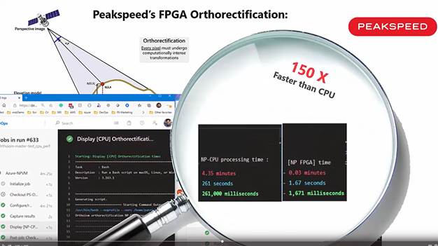
For example, orthorectification involves evaluating compute-intensive sensor models for each output pixel being generated. The increase in data volume and requirements for lower latency has necessitated workarounds to achieve an acceptable throughput. These workarounds rely on interpolation schemes to avoid evaluating the sensor model at every pixel, thus sacrificing output pixel location accuracy. As the image and elevation data resolutions increase, providers are forced to either increase hardware capacity, or decrease the location accuracy, or both. The pipelining nature of FPGAs, on the other hand, allows for rigorous computation at every pixel in the orthorectified image, independent of image or DEM resolution, while simultaneously increasing throughput by orders of magnitude compared with CPU solutions.

Another benefit of the use of FPGAs is the weight and power requirements. Because FPGAs are more efficient compute engines, a typical application will require much fewer cores in comparison to CPUs and GPUs. The improvements can range from 50% to 90% reduction in compute needs along with the correlated net reductions in weight and power usage.

Peakspeed Ortho

Product presentation: Orthorectification up to 500x faster

Peakspeed Ortho consists of a high performance orthorectification engine running on the Alveo card along with an image orchestration engine running on the host server. Users can expect orthorectification times 100X to 200X faster than their equivalent CPU-based implementations, and batch throughput around 1 GB/s.

EVALUATE FOR FREE

On the Xilinx App Store

Share on:

Share on linkedin
LinkedIn
Share on twitter
Twitter
Share on facebook
Facebook
By Jean-Michel Frouin on 11 January 2021